Last Updated on September 11, 2024 by Rihanna
LPA Develops Into Tropical Storm, May Enter PH Friday or Saturday
-ADVERTISEMENT-

Introduction to the Developing Tropical Storm
As meteorologists closely monitor the weather, a Low Pressure Area (LPA) has shown signs of intensifying into a tropical storm.
According to the Philippine Atmospheric, Geophysical, and Astronomical Services Administration (PAGASA), the LPA is likely to enter the Philippine Area of Responsibility (PAR) between Friday and Saturday, bringing potential heavy rainfall and strong winds to parts of the country.
Understanding the situation, staying informed, and preparing adequately are essential steps to ensure safety during the storm.
What is a Low Pressure Area (LPA)?
An LPA is a weather system characterized by lower atmospheric pressure compared to surrounding areas. It often forms due to rising warm air, which creates a vacuum that draws in surrounding air. As an LPA intensifies, it may develop into a tropical depression or tropical storm, depending on wind speeds and atmospheric conditions.
This LPA is currently under close observation, as it is expected to strengthen and bring potential weather disruptions to the Philippines.
ADVERTISEMENT-

How an LPA Develops Into a Tropical Storm
An LPA can evolve into a tropical storm when it gains enough moisture and heat from the ocean’s surface. As the warm air rises, it forms thunderstorms that coalesce into a larger, more organized system.
The Coriolis effect, caused by the Earth’s rotation, allows the storm to spin and further intensify, potentially reaching wind speeds of 62 km/h or more, at which point it is classified as a tropical storm.
Weather Forecast: When Will the Storm Enter the Philippines?
The latest PAGASA advisories indicate that the tropical storm may enter the Philippine Area of Responsibility (PAR) on Friday or Saturday. Once inside the PAR, the storm will be named according to the local list of typhoon names. It is important for residents in affected areas to stay updated through official weather channels to track the storm’s progress.
Current Tracking of the Storm’s Path
Meteorological models predict that the storm could affect parts of Luzon and Visayas, though its exact path is subject to change. The storm may cause widespread rainfall, potentially leading to flooding in low-lying areas and landslides in mountainous regions.
| Date | Weather Condition Forecast | Affected Regions |
|---|---|---|
| Friday Morning | LPA continues to intensify, light rains | Eastern Visayas, Northern Luzon |
| Saturday Evening | Storm enters PAR, heavy rains expected in several areas | Bicol Region, Metro Manila, Southern Luzon |
| Sunday Morning | Storm fully within PAR, strongest winds and rains expected | Central and Northern Luzon, Eastern Visayas |
How Meteorologists Track the Development of Tropical Storms
Meteorologists use several tools and techniques to track and forecast the development of tropical storms. Some of the key methods include:
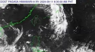
- Satellite Imagery: Allows real-time observation of cloud formations and storm movements.
- Weather Models: Predict the storm’s potential path and strength using computational models based on historical data.
- Doppler Radar: Tracks rainfall intensity and storm direction over time.
These tools help PAGASA and other meteorological agencies provide accurate forecasts, allowing for timely public warnings and preparedness efforts.
Possible Areas Affected by the Tropical Storm
The tropical storm is expected to bring varying degrees of rainfall and wind speeds to several regions across the Philippines. The regions most likely to experience significant impacts include:
- Luzon: Northern and Central Luzon could see heavy rains, particularly in Cagayan, Isabela, and Aurora provinces.
- Visayas: Eastern Visayas, particularly Samar and Leyte, are forecasted to receive torrential rains and possible flash flooding.
- Metro Manila: The capital region may experience moderate to heavy rainfall, potentially causing urban flooding.
Preparedness Tips for Residents in Affected Areas
It is crucial for residents in areas that may be affected by the storm to prepare in advance. Here are some key steps to ensure safety:
What to Do Before the Storm Hits
- Stock Up on Essentials: Prepare enough food, water, and medicine to last for several days.
- Charge Electronic Devices: Ensure mobile phones and power banks are fully charged.
- Secure Your Home: Reinforce windows, doors, and roofs to withstand strong winds.
Essential Items to Prepare
| Item | Purpose |
|---|---|
| Emergency Kit | Contains first aid supplies, flashlight, batteries, etc. |
| Food and Water | Enough to last at least 72 hours |
| Important Documents | Store in waterproof containers |
Government and Local Authorities’ Response Plans
Government agencies and local authorities have already begun implementing their disaster response plans. PAGASA, the National Disaster Risk Reduction and Management Council (NDRRMC), and local government units (LGUs) have issued early warnings and are preparing for possible evacuations.
Current Advisories from PAGASA
PAGASA continues to issue hourly updates on the storm’s development, urging residents to monitor official announcements and heed evacuation orders if necessary. The agency is coordinating closely with local governments to ensure preparedness measures are in place.
Evacuation Plans and Relief Efforts
In flood-prone areas, evacuation centers are being prepared to accommodate displaced residents. Relief supplies, including food, water, and medical assistance, are being pre-positioned to ensure prompt delivery during the storm.
Potential Impact on Daily Life and Travel
The tropical storm is expected to cause disruptions to daily activities, including work, school, and travel. Here are some key areas that may be affected:
- Public Transportation: Flights may be canceled, and road travel may be hindered due to flooding and landslides.
- Business Operations: Some businesses may close temporarily, especially in heavily affected areas.
- School Cancellations: Classes may be suspended in regions under storm warning signals.
-ADVERTISEMENT-

The Role of Climate Change in Intensifying Storms
Climate change is playing a significant role in the increasing frequency and intensity of tropical storms. Rising ocean temperatures provide more energy for storm systems, causing them to intensify more quickly and reach higher wind speeds. The Philippines, being located in a typhoon-prone area, is particularly vulnerable to these climate-related impacts.
The Connection Between Climate Change and Extreme Weather Events
Scientists agree that climate change is contributing to more extreme weather events worldwide. Warmer oceans lead to more intense storms, while changing weather patterns can cause storms to linger longer, increasing the risk of prolonged heavy rainfall and flooding.
Safety Tips During the Tropical Storm
During the storm, it’s important to take necessary precautions to stay safe. Here are some essential tips to follow:
- Stay Indoors: Avoid going outside during the storm unless absolutely necessary.
- Monitor Weather Updates: Keep track of the latest weather advisories from PAGASA.
- Avoid Flooded Areas: Do not attempt to cross flooded streets or rivers, as water levels may rise quickly and pose a risk of drowning.
Precautions for Flood-Prone Areas
- Elevate furniture and appliances in low-lying homes.
- Stay in contact with local authorities to receive evacuation alerts.
Post-Storm Recovery: What to Expect After the Storm Passes
Once the storm has passed, recovery efforts will begin to restore normalcy in affected areas. Here’s what to expect during the recovery phase:
- Clean-Up Efforts: Local authorities and residents will work together to clear debris, restore power, and ensure roads are passable.
- Restoring Essential Services: Utilities like water and electricity may take some time to be fully restored in heavily affected areas.
Government Assistance for Affected Families
The national government and local authorities will provide aid to families affected by the storm. Relief packages containing food, water, and hygiene supplies will be distributed to evacuation centers and communities in need.
Read More About this Tropical Storm👉 LPA develops into tropical storm, may enter PH Friday or Saturday | The Manila Times
Disclaimer
The information provided in this article is based on the latest weather updates from PAGASA and other sources. The situation may change, and readers are advised to stay tuned to official announcements and advisories for real-time information.
User Reviews
John D.
“The forecasts from PAGASA helped us prepare early for the storm. We stocked up on essentials and followed their advisories, which gave us peace of mind during the storm.”
Maria S.
“Living in a flood-prone area, we were concerned about the storm, but local authorities were very responsive and set up evacuation centers in time. The preparation made all the difference.”
Frequently Asked Questions
When will the storm hit the Philippines?
The storm is expected to enter the Philippine Area of Responsibility (PAR) between Friday and Saturday, according to the latest PAGASA forecast.
What areas will be affected by the storm?
The storm is likely to affect parts of Luzon, Visayas, and Metro Manila, with potential heavy rainfall, flooding, and strong winds.
How can I prepare for the tropical storm?
Residents in affected areas should stock up on food, water, and medicine, secure their homes, and follow any evacuation orders from local authorities.
Is the storm related to climate change?
While this specific storm is a natural weather event, climate change is contributing to more frequent and intense tropical storms by warming ocean temperatures.
What should I do if flooding occurs in my area?
If your area is prone to flooding, evacuate to higher ground and follow local government advisories. Avoid wading through floodwaters, as they may be contaminated or have strong currents.
Conclusion: Staying Informed and Prepared
Tropical storms are a common occurrence in the Philippines, but with proper preparation and timely information, their impact can be mitigated.
By staying informed, following PAGASA advisories, and taking necessary safety precautions, residents can navigate the storm with greater confidence and security.
Related Topics

Rihanna Cruz, is a wordsmith seasoned in three years of online gaming journalism, captivates readers with her passion-fueled articles. She translates complex mechanics into engaging narratives, offering insightful perspectives on mobile RPGs, esports psychology, and more.